What matters most?
Determining what matters most to the community is fundamental to selecting adaptation options (e.g., if the beach is valued highly, options that could lead to the loss of the beach would not score well).
Community values (MfE Step 3: Values and Objectives)
As part of the 2019/20 Summer Survey, respondents were asked to rank the importance of pre-selected values relating to the coastal environment. That is:
-
Appearance of the coast.
-
Good recreational facilities.
-
A dry sandy beach (at high tide).
-
Easy access onto the coast.
-
A healthy natural environment.
-
Walking access along the full length of the beach.
-
Maintaining personal or family connections.
-
Protecting places of historic and/or cultural significance.
-
Protection of scenic values.
In November 2020, through a facilitated workshop, Coastal Panel members were also asked to comment on what they value about their sections of the coastline. The results are presented by Coastal Panel area and for the Coromandel Peninsula as a whole (see images below). They take the form of ‘word clouds’ that weight (increase the size of) repeated and other key words.
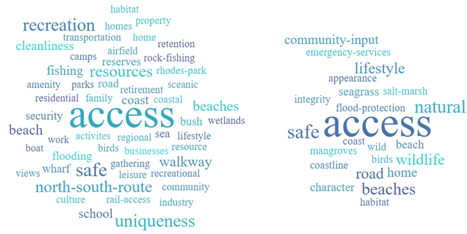
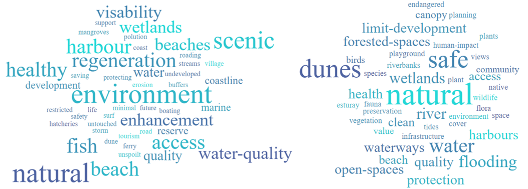
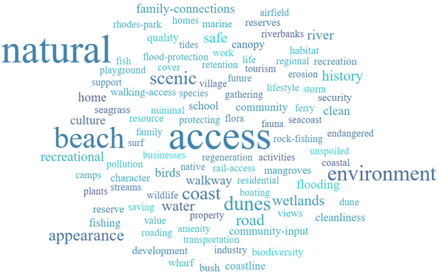
Given this context, the objectives for the CAPs were revisited and the need to protect people, essential services and lifeline infrastructure, providing a safe place to live now and for our children's children, was recognised as preeminent amongst them (see "Principles and Objectives"). The need to maintain access and functioning ecosystems (where possible), and to provide for recreation, where also recognised as critical. Overall, ‘access’ and maintaining a ‘natural’ environment were the values identified as being of the highest importance to the communities of the Coromandel Peninsula; and were identified as being equally important.
Risk assessment (MfE Step 4: Vulnerability and Risk)
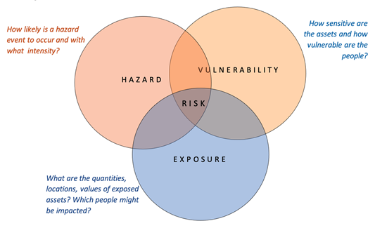
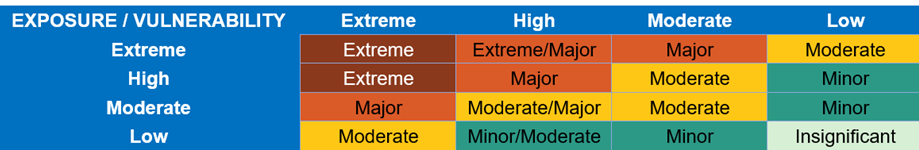
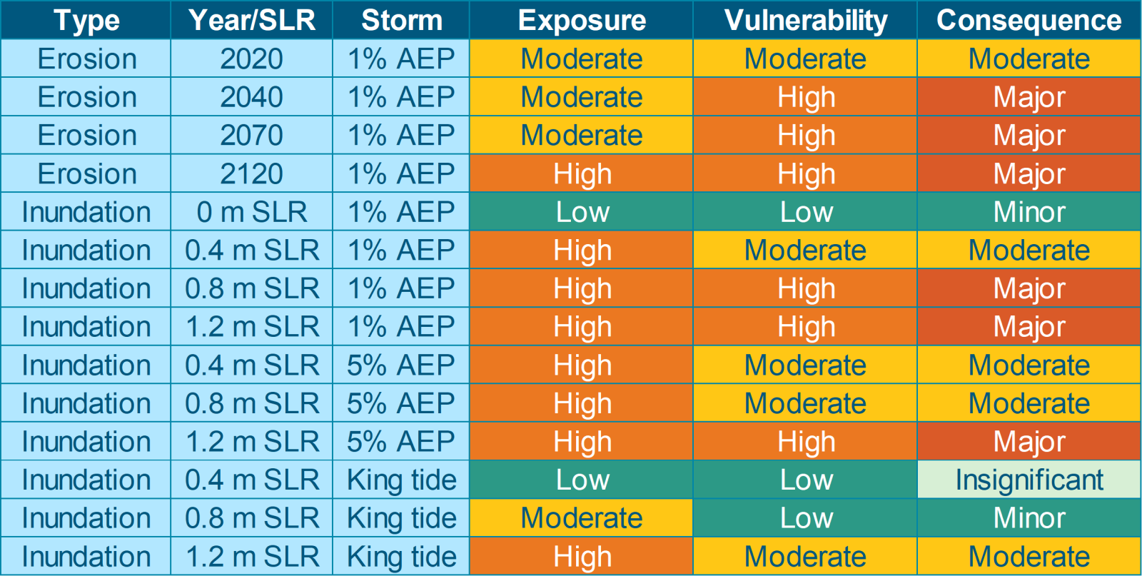
Step 2 of the SMP process defined the ‘hazards’ of concern and hazard ‘likelihood’ and mapped the predicted ‘exposure’ of the Peninsula to coastal inundation, erosion and instability. However, potential exposure to a hazard does not directly equate to the presence of a moderate or high risk. Risk is generally defined through a combination of the three components shown in the figure below ("Conceptualisation of risk") and needs to consider the ‘vulnerability’ of the receptor to the hazard. That is, the vulnerability of a sports field to coastal inundation is low (because a field can “cope” with an inundation event) and, consequently, there is low risk. By contrast, the vulnerability of a school, hospital or retirement village to coastal inundation will be high or extreme and the risk (dependant on the extent and depth of inundation) is likely to be major or extreme. Hence the vulnerability of people, the natural environment, valued assets and infrastructure (e.g., a low lying old wooden building by contrast to a modern raised brick building), based on their ‘sensitivity’ to the hazard as well as their ‘adaptive capacity’ (ability to respond), will affect the assessment of risk (see risk map below).
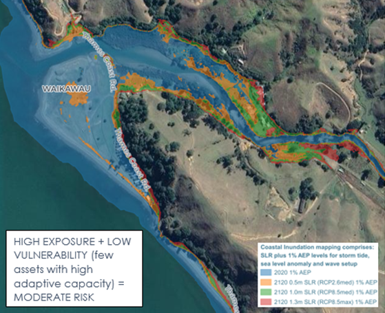
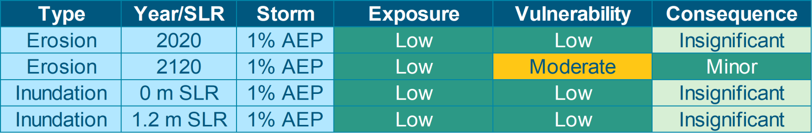
For this project, the first pass risk assessment (undertaken as part of Step 1) focused on identifying those areas where coastal hazards (erosion, inundation, tsunami, landslides and river flooding) are most likely to impact over the next 100 years and where the associated risk was predicted to be significant. It defined the priority areas for more detailed hazard assessment (MfE Step 2). The matrix below provides an example of the assessed risk for a low-risk Policy Unit (not assessed further in the second stage).
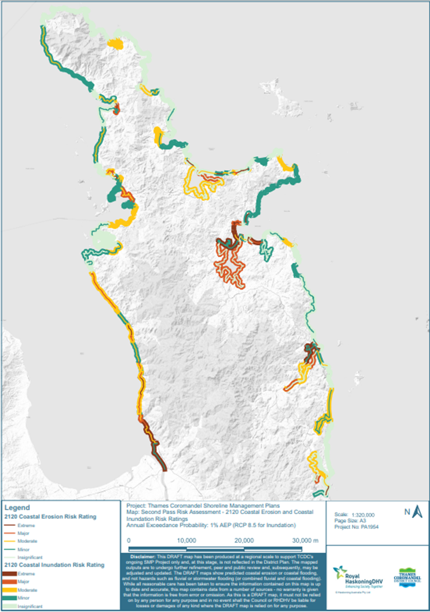
The second pass risk assessment (MfE Step 4) used the outputs from the detailed coastal erosion and inundation modelling, the instability assessment and other sources of available information where detailed modelling was not available (e.g., the WRC Inundation Tool and TCDC’s Current and Future Coastal Erosion Lines[1]), to define and quantify the potential exposure of the built environment, natural environment, society and culture (our ‘value domains’) to coastal hazards. Vulnerability and consequence ratings were then derived, and risk was determined for all 400km of the Coromandel Peninsula’s coastline based on the combination of exposure and vulnerability (see "Risk assessment matrix" below). An example of the risk assessment for Rings Beach is provided in the summary matrix below.
The figure that follows shows the outputs from the second pass risk assessment for the whole Peninsula. The risk assessment matrix includes details of the assets potentially exposed to erosion and inundation for each value domain.
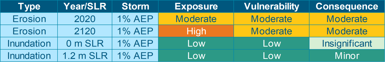
The third pass risk assessment built on the second pass by incorporating additional data, additional storm scenarios and SLR increments, and improved quantification of what was predicted to be potentially exposed to coastal inundation and coastal erosion. It was focused on those Policy Units (stretches of coast) expected to be most at risk. The approach and methodology adopted was developed in collaboration with TCDC and WRC staff. An example risk assessment summary from the third pass risk assessment for Te Puru North is provided in the matrix below. The risk assessment matrix includes details of the assets potentially exposed to erosion and inundation for each value domain.
This approach varied from the approach set out in the MfE’s (2017) guidance:
-
First pass risk assessment – desk top study to screen climate change related exposure was undertaken for the SMP project in its scoping stage (Step 1 of the MfE’s process, see "The dynamic adaptive planning process"), earlier than advocated in the guidance - which suggests that it is undertaken at the end of Step 2 (hazard assessment) - given the over 400km of coast to be assessed for the Peninsula and the need to focus on those areas at risk (and exclude those not at risk) from the project’s outset.
-
Second pass risk assessment – for this phase a standard risk-based approach using national, regional and local information (input from the hazard assessments and on demographics and asset attributes) and expert knowledge was undertaken in line with Step 4 of the MfE process.
-
Third pass risk assessment – was undertaken at the end of Step 6 of the MfE process (option evaluation) as advocated but focused on further investigation of short-listed risks for the highest priority locations (for which more refined modelling outputs were available) and prioritisation and testing of policies (e.g., ‘accommodate’ or ‘protect’) and options (e.g., raise floor levels or enhance dunes through planting) to reduce the identified risk to a tolerable level, rather than evaluation of the effectiveness of response options in reducing risk. That is, options that could reduce the risk to a tolerable level were shortlisted but for each option an assessment of the change in the risk rating (e.g., extreme to insignificant) was not undertaken.
The reason for this re-evaluation of the risk not being undertaken is that the coastline of the Coromandel Peninsula has 141 Policy Units, 92 of which required adaptation pathways (i.e., greater than a low risk was identified), and almost all of these include multiple points in time where a new course of action (pathway) is likely to be required, for which several options were available in each case. Over 2000 evaluations of the predicted reduction in the risk would have had to be undertaken in this case. Moreover, the effectiveness of an action on an adaptation pathway that follows from a previous action, will be dependent on the previous action, for which there could be many options (which would have increased the assessment requirement ten-fold).
Footnotes
- 1 Included in the District Plan.