Community led
Strategy
The involvement of the community in the project is detailed in a Communications and Engagement Strategy. This was initiated in the project’s scoping phase and proposed a tiered approach to communications and engagement. The approach allowed for both broad public participation and intensive, locally specific collaboration between key stakeholders and individual citizens in developing CAPs for the Coromandel coast. That is, each technical step in the process was supported by targeted and specific engagement initiatives (see figure below).
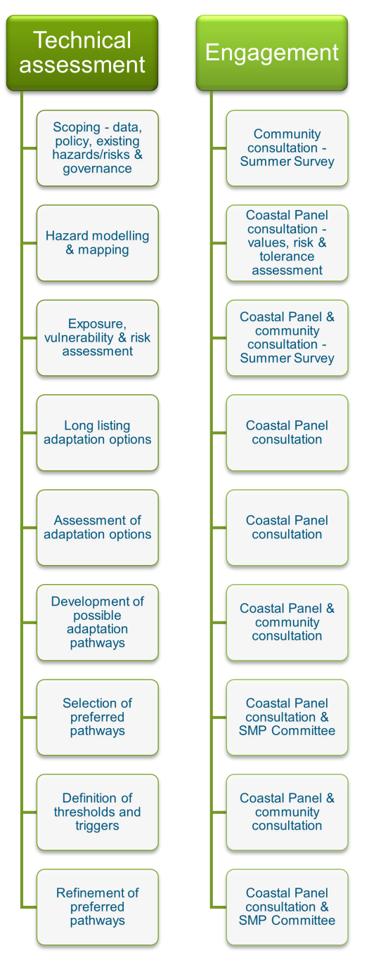
Critical to this approach was the establishment of a project governance structure and the development of Coastal Panels. These Coastal Panels covered different parts of the district to represent the views of their communities, work through the coastal adaptation challenges and recommend solutions.
Also included were regular communications through the TCDC website; a newsletter, fact sheets and public surveys; community open days; and presentations to gather detailed information on:
-
community understanding of coastal hazards and their consequences;
-
what is valued about the Coromandel’s coastal environment; and,
-
appropriate/inappropriate adaptation responses.
Project governance
The governance framework adopted for the project in August 2020 is set out in the figure below and reflects TCDC’s obligations under the Te Tiriti o Waitangi. The SMP Governance Committee was established as TCDC’s first co-governance Committee of Council[1]. It is jointly chaired by and made up of four elected representatives each from TCDC and Pare Hauraki. This Committee, which met quarterly, provided direction to the project and had the delegation to approve and adopt the CAPs. TCDC are responsible for implementation of the recommendations that relate to its assets and responsibilities.
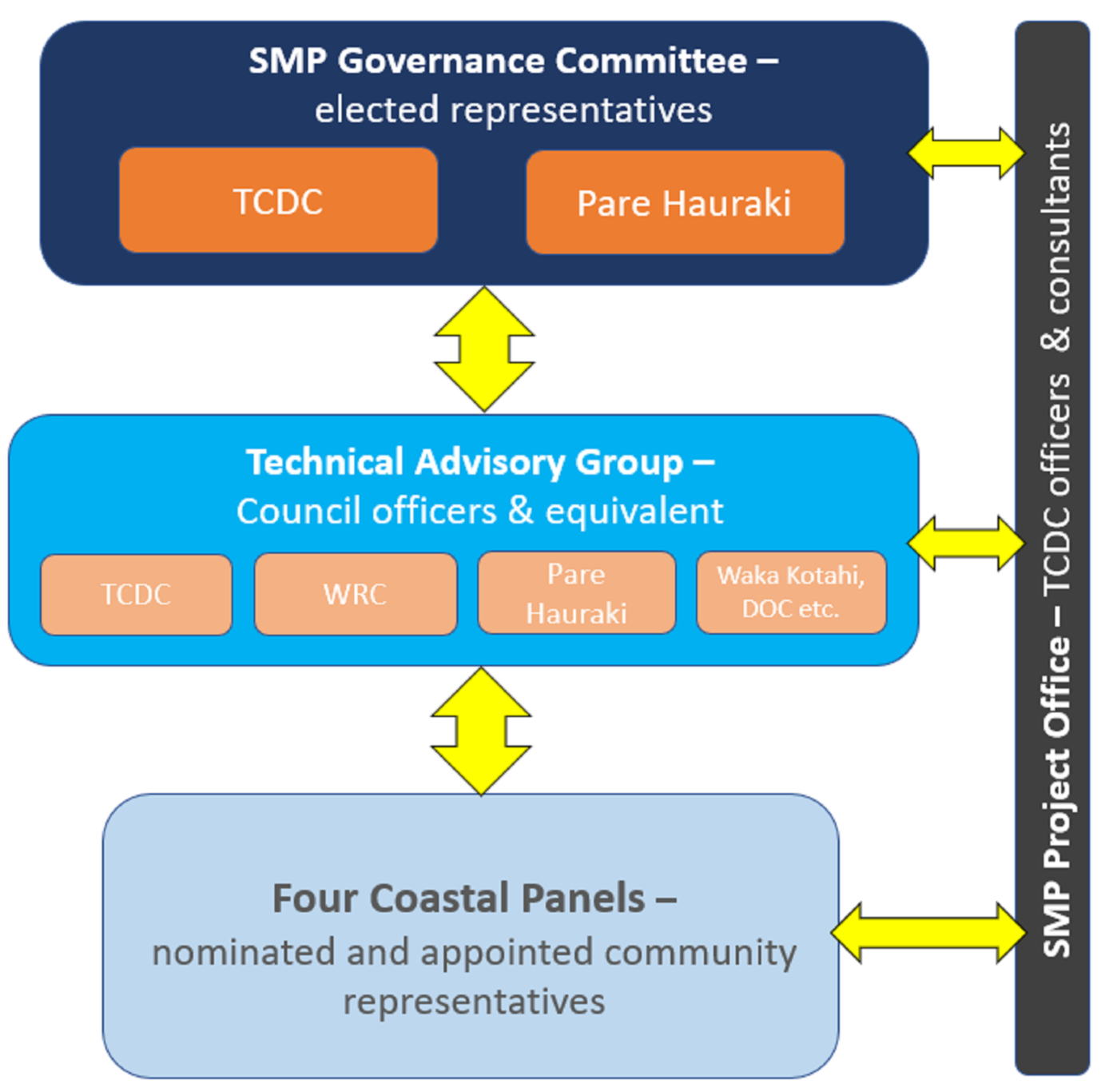
Technical Advisory Group
The Technical Advisory Group (TAG), which initially met bi-monthly (or as required) and then monthly, was made up of senior officers of the organisations represented and provided technical and strategic advice on, and peer review of, the project methodology and outputs[2]. Members of the TAG also supported the Coastal Panel meetings where appropriate. The input to the project provided by Waikato Regional Council (WRC), Waka Kotahi (the New Zealand Transport Agency (NZTA)) and Pare Hauraki has been significant.
Coastal Panels
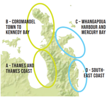
Coastal Panels were set up for the following areas:
-
Thames and the Thames Coast (Kopu to Kereta).
-
The Coromandel Coast to Kennedy Bay.
-
Whangapoua Harbour and the Mercury Bay Coast (to Hot Water Beach).
-
The Southeast Coast (Tairua through to Whangamata).
Their objective was the co-development of coastal adaptation pathways, with TCDC and its experts, that recommended an agreed course of action for the stretch of coast in question[3].
Coastal Panels were location-specific, matched to coastal compartments and linked to existing governance arrangements where possible, e.g., TCDC Community Boards and wards, WRC catchment committees, Civil Defence and Emergency Management community groups.
Membership was sought from Mana Whenua, Community Boards, community organisations (e.g., residents and rate payers’ groups), business and citizens. Mana Whenua and the Community Boards were asked to nominate representatives for each Coastal Panel directly. For community organisations, business and citizens, expressions of interest were invited through TCDC’s website, advertisements, and word of mouth.
Over 50 expressions of interest were received, and members selected with the intention of achieving a balance, as far as possible, vis-à-vis age, gender, interests, knowledge, a diversity of views and location. This resulted in around 8 community members being selected onto each Coastal Panel, in addition to the Community Board representatives.
Panel members were tasked with representing the views of their community and working through the development of CAPs based on the steps set out in MfE’s guidance, supported by technical experts.
Community Engagement
The work of the Panels was augmented by traditional, broader forms of public consultation at key milestones[4]. These broader processes allowed Panels to justify, clarify, and revise recommendations in response to public feedback.
The table below summarises the information provision[5] and consultation undertaken.
Consultation summary
Form | Details | Number |
TCDC website | The provision of information on the SMP page, https://www.tcdc.govt.nz/smp. This included details of and minutes from all Coastal Panel meetings. | Page updated at least monthly for three years |
Electronic direct mail | Updates to registered interested parties | 35 |
Press releases | On events and progress | 30 |
Social media posts | On events and progress | 85 |
Radio | Radio interviews via Mayoral updates | Monthly |
TCDC magazine | Articles on progress and outcomes | Three (annual) |
Project overview video available on TCDC’s website, Facebook, Instagram etc. | One | |
Project updates and information | Three | |
(i) An introduction to SMPs, (ii) Iwi engagement, (iii) Who does what in the coastal environment (vis-à-vis WRC and TCDC), (iv) Regional sea level rise, and (v) Local coastal storms | Five | |
(i) An introduction to SMPs, (ii) What are our coast hazards? (iii) Defining the risk from the hazard, (iv) What is the risk over the next 100 years? (v) How do we plan to manage the shoreline? (vi) A strategy for shoreline management planning, and (vii) Definitions | Seven | |
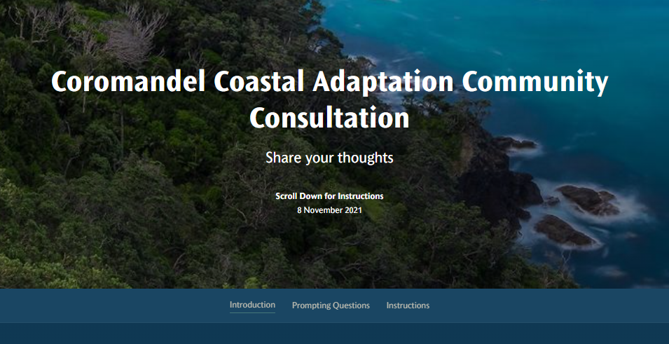
Community consultation events | Public meetings were held in 8 to 12 locations around the Peninsula (including Thames, Moanataiari, Te Puru, Tararu, Coromandel Town, Colville, Kennedy Bay, Whangapoua, Matarangi, Kuaotunu, Wharekaho, Ohuka, Whitianga, Cooks Beach, Tairua, Pauanui and Whangamata), for each series, on five occasions (four face-to-face and one online series). These events covered:
| Over 50 public meetings attended by some 1,250 people attended and took part these events[6] |
Posters & adverts | Notifications relating to public meetings, including posters placed on community notice boards and some letterbox drops, newspaper adverts (all regional papers) and direct mailouts to targeted at risk communities. | Five series (as above) plus monthly newspaper adverts, 400 letterbox drops and 1,500 letters. |
(i) To gauge community understanding of coastal hazards and understand what the community values (Summer Survey 2019/20), and (ii) On confidence in the coastal hazard predictions, preferences regarding adaptation options and who should pay (Summer Survey 2021). | Survey 1 – 905 respondents (online); Survey 2 – 81 respondents (at events) | |
OurCoast email | Maintenance of an OurCoast email address – ourcoast@tcdc.govt.nz – for feedback, questions and comments, and for recording the outputs from CoastSnap stations (photos of coastal change recorded by the public at fixed locations, e.g., Ohuka). | Maintained throughout the project, with over 100 emails noted and responded to. |
Coastal Panel workshops | The DAPP process was informed by presentations on (amongst others):
| 14 + workshops for each panel (i.e., over 56 workshops) |
Targeted meetings | Specific one-to-one meetings were held with at risk communities or locations, including in Moanataiari, Manaia, Wyuna Bay, Koputauaki Bay, Kennedy Bay, Buffalo Beach and Robinson’s Road Whitianga, and the southern end of Ocean Beach Pauanui. | More than 10 |
Feedback on the information presented was sought and obtained in a number of ways, including verbally at consultation events, through ‘Post-it Notes’ added to event posters and feedback forms, via the project’s online consultation feedback tool (on TCDC’s SMP webpage) and through emails to the OurCoast email address. All feedback received has been considered.
Full details of the consultation undertaken are provided in the Communications and Engagement Strategy. This activity has generated earned media (i.e., national and regional media interest) on at least 20 occasions (in print and on radio and television).
Footnotes
- 1 Committee of Council Terms of Reference
- 2 TAG Terms of Reference
- 3 Coastal Panel Terms of Reference
- 4 In line with the ‘special consultation procedures’ included under the Local Government Act 1993
- 5 Hazard maps (including 20cm sea level rise increments for 1 in 100 year, 1 in 20 year and kind tide events), risk assessments, technical reports, meeting agendas and minutes, draft coastal adaptation pathways, and a Consultation Feedback Tool.
- 6 Note that some individuals, who attended more than one meeting, will be double counted in this number.